NOAA All Hazards Radio has been around since 1960. I have a Midland Weather Radio receiver in my house because we live in a rural area. We certainly do have weather events; Severe Thunderstorms being the most common. We have also had Tornados, Floods, Hurricanes, Winter Storms and Blizzards. It is useful to have, especially when the cell phone and/or public network go down.
That system operates on the same frequencies and manner as the NOAA All Hazards Radio system.
It appears that the Canadian government is discontinuing service as of March 16, 2026 and replacing it with an app. That seems short sighted to me; I don’t know how many users of Weather Radio Canada there are, but I’d bet there are quite a few. It also assumes that everyone in Canada has a smart phone. Given the economy and the expense of a new iPhone (or Android), I think this is far from the case.
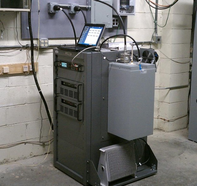
Nautel NG1000 NOAA transmitter
I did get thinking about what would happen here if the NOAA system went away. Could the Emergency Alert System still get reliable local alerts out over the air? I know that most of the radio and TV stations in this area still monitor the NOAA frequencies as a third source for local activations. Over the years, EAS activation for things like Tornado Warnings has saved quite a few lives, especially out in the mid west.
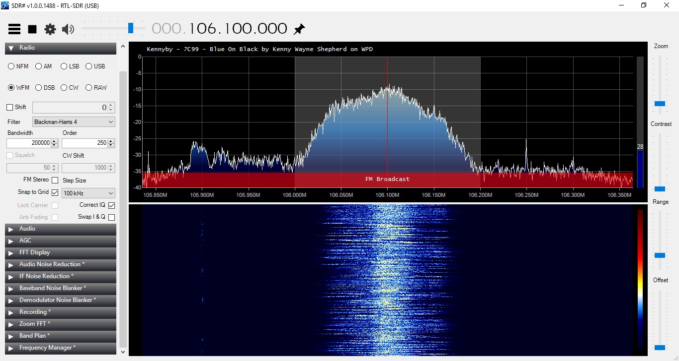
In my spare time (lol!) I have been fooling around with one of those RTL 2832U dongles and a bit of software. For those that don’t know, the RTL 2832U is a COFDM demodulator chip designed to work with a USB dongle. When coupled with an R 820T tuner a broadband RF receiver is created There are many very inexpensive versions of these devices available on Amazon, eBay, and other such places. The beauty of these things is that for around $12-30 and a bit of free software, one can have a very versatile 10 KHz to 1.7 GHz receiver. There are several good software packages for Windoze, Linux, and OSX.
The one I recommend for beginners is called SDR-Sharp or SDR#. It has a very easy learning curve and there is a lot of documentation available online. There are also several worthwhile plugins for scanning, trunking, decoding, etc. At a minimum, the SDR software should have a spectrum analyzer, waterfall display, and the ability to record audio and baseband PCM from the IF stage of the radio.
Some fun things to do; look at the output of my reverse registering smart (electric) meter (or my neighbor’s meter), ACARS data for the various aircraft flying overhead, a few trips through the EZPass toll lanes, some poking around on the VHF hi-band, etc. I also began to think of Broadcast Engineering applications and a surprising number of things came to mind:
Using the scanner to look for open 950 MHz STL frequencies
Inexpensive portable FM receiver with RDS output for radio stations
Inexpensive Radio Direction Finder with a directional antenna
Inexpensive Satellite Aiming tool
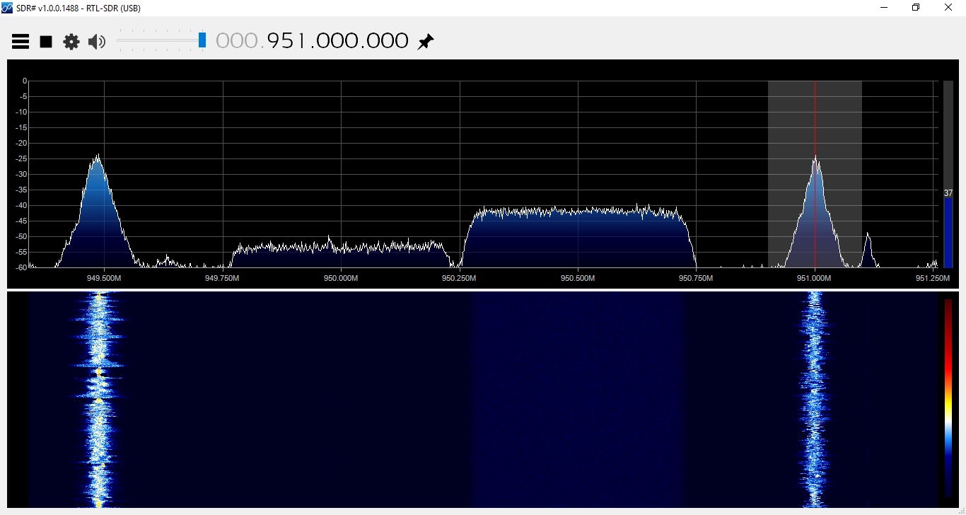
Using SDR sharp and a NooElec NESDR Mini+ dongle, I made several scans of the 945-952 STL band in a few of our markets. Using the scanner and frequency search plugin, the SDR software very quickly identified all of the in-use frequencies. One can also look at the frequency span in the spectrum analyzer, but this takes a lot of processing power. The scanner plugin makes this easier and can be automated.
Analog and digital 950 MHz STL frequencies, Albany, NY
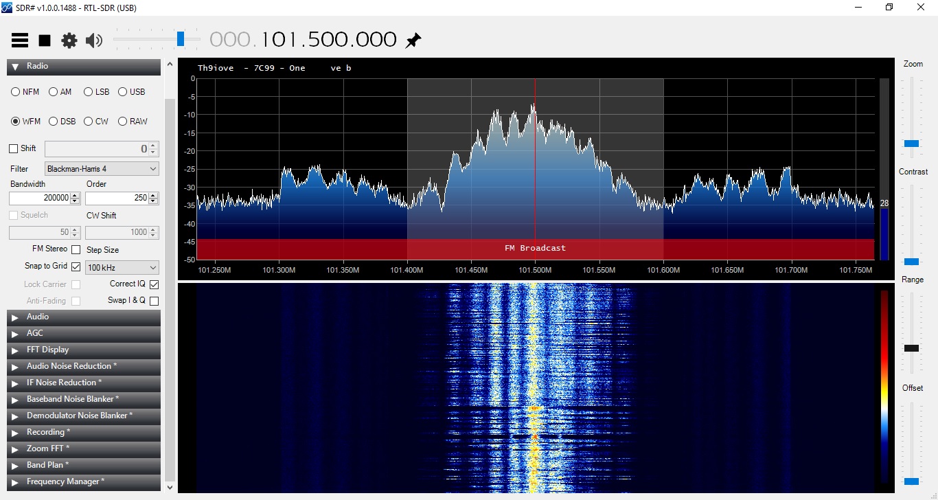
I also listened to the analog STLs in FM Wideband mode. Several stations are injecting their RDS data at the studio. There is one that appears to be -1500 Hz off frequency. I’ll let them know.
Next, I have found it beneficial just to keep the dongle and a small antenna in my laptop bag. Setting up a new RDS subcarrier; with the dongle and SDR# one can quickly and easily check for errors. Tracking down one of those nasty pirates; a laptop with a directional antenna will make quick work.
Something that I found interesting is the waterfall display for the PPM-encoded stations:
WPDH using RTL 2832U and SDR Sharp
Not only can you see the watermarking on the main channel, you can also see the HD Radio carriers +/- 200 KHz from the carrier frequency. That is pretty much twice the bandwidth allotment for an FM station.
WDPA using RTL 2831U and SDR Sharp
Those two stations are simulcasting. WPDA is not using Nielson PPM nor HD Radio technology. There is all sorts of interesting information that can be gleaned from one of these units.
Aiming a satellite dish at AMC-8 can be a bit challenging. That part of the sky is pretty crowded, as it turns out. Dish pointer is a good general reference (www.dishpointer.com) and the Dish Align app for iOS works well. But for peaking a dish, the RTL 2832 dongle makes it easy to find the correct satellite and optimize the transponder polarization. Each satellite has Horizontal and Vertical beacons. These vary slightly in frequency, thus, but by tuning to the correct beacon frequency, you can be assured that you are on the right satellite. All of the radio network programming on AMC-8 is on vertically polarized transponders, therefore, the vertical beacons are of interest. Here are the vertical beacons for satellites in that part of the sky:
Satellite
Position
C band Vertical beacon (MHz)
L band (LNB) Vertical beacon (MHz)
Comment
AMC-8
139W
4199.5
949.25
AMC-7
137W
3700.5
1450.25
GOES15
135.4W
2209.086
N/A
NOAA WX
AMC-10
135W
4199.5
949.25
Galaxy 15
133W
4198
949.00
AMC-11
131W
4199.5
949.25
Galaxy 12
129W
3700.5
1450.25
For those in the continental United States, there is not much else past 139W, so AMC-8 will be the westernmost satellite your dish can see. Of course, this can be used in other parts of the world as well, with the correct information. Bringing a laptop or Windows tablet to the satellite dish might be easier than trying to drag a XDS satellite receiver out.
AMC8 vertical beacon output from LNB
In order to use the RTL-2832U, simply split the output of a powered LNB, and install a 20-30 dB pad in between the splitter and the dongle. Using the vertical beacon on 949.25 MHz, adjust for maximum signal.
For some other uses; look for the nearest and best NOAA Weather radio station. Several times the local NOAA weather station has been off the air for an extended period of time. Sometimes, another station can be found in the same forecast area. Heck, couple these things to a Raspberry Pi or Beaglebone black, and a really nifty EAS receiver is created for NOAA and broadcast FM. One that perhaps, can issue an alarm if the RSL drops below a certain threshold.
I am sure there are plenty of other uses that I am not thinking of right now…
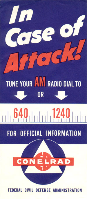
Even before CONELRAD was introduced in 1951, radio broadcasting was a critical part of the emergency communications infrastructure. The government recognized early on the ability of radio to transmit data and information quickly, over large areas to the general public. It works when all other systems fail, as demonstrated repeatedly over the years, the last of which occurred during Hurricane Sandy last October. Massive destruction from flooding in lower Manhattan and shoreside Brooklyn rendered the electrical grid, telephone network, cellular network, and the internet out of order. Fortunately, enough radio stations stayed on the air and people used battery-powered AM and FM receivers to obtain information.
CONELRAD poster, circa 1950’s
CONELRAD served two purposes; first, radio stations either re-tuned their transmitters to 640 or 1240 KHz or switched off the air. Then, each station that was still on the air would transmit for ten minutes, after which, they turned off and the next station in the chain would turn on and transmit for ten minutes. This was designed to confuse the Soviet bombers flying over the north pole on their way to incinerate us. Secondly, the CONELRAD stations were to distribute emergency information during and after the said attack.
CONELRAD receiver
Recently, I found this CONELRAD receiver in a bomb shelter at a radio station. It dates to pre-1963, which is when CONELRAD was replaced by EBS.
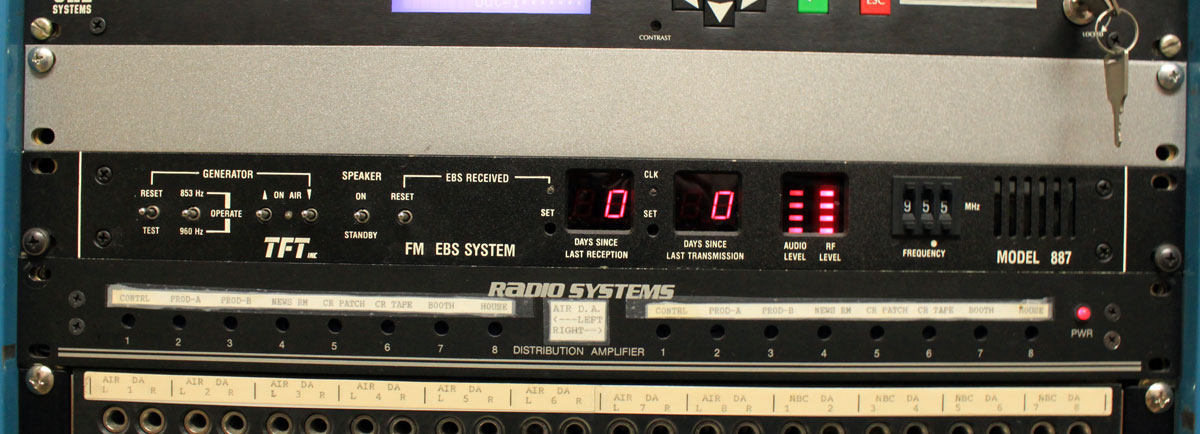
EBS encoder/decoder
EBS or the Emergency Broadcast System was a refinement of CONELRAD in several areas. EBS used a two-tone attention signal to unmute receivers and alert the public that something important may be happening. Initially designed as a national system to warn of an impending attack, in later years it was also used by state and local governments to warn of other emergencies like weather, etc.
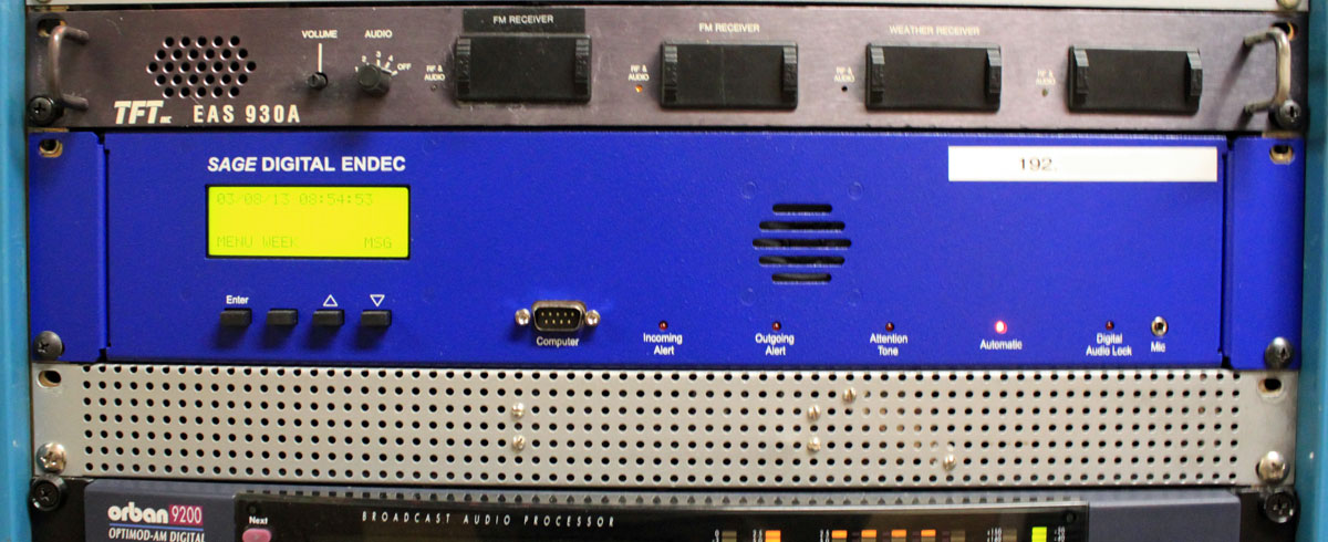
The current system is EAS or Emergency Alert System.
CAP compliant EAS
The Emergency Alert System was an advancement of the EBS in several areas. Using SAME protocol in the message headers allowed stations to automate alert message relays. This was driven by the desire for unattended operation. The use of SAME also allowed many different types of messages to be filtered by alert type and area. Each EAS unit also had an internal voice recorder. All of this was upgraded in 2011 with the introduction of CAP, which would take email messages and generate computer voice alerts to be sent out over broadcast stations.
Three generations of emergency communications equipment found at one facility.
The main problem with EAS CAP is it violates the engineering principle of KISS (Keep It Simple, Stupid). It is an overly complicated system that relies on the internet, e-mail servers, the public telephone system, and other infrastructure that may not survive natural or man-made disasters, enemy attacks, or other disruptions. Even something as simple as a national test proved to be problematic in 2011.
For a real emergency information network, the idea of WGU-20 has some merit. Two or more well-positioned medium to high-powered LF stations could serve as a PEP distribution network and reliably cover the entire country. With such a system, every broadcast station, cable head end, and NOAA radio transmitter could monitor the LF stations directly, thus replacing most of the over-the-air daisy chain and or FEMA leased lines. The advantages of LF is that it is fairly immune to HEMP, it goes a long way reliably, can have multiple redundant transmitter sites located within secure areas like military bases, and uses time-proven technology. That would be a real, cold war solution. But no, let us instead rely on a hodge podge of ISPs, TELCO leased lines, 3/4G wireless networks, SMS, satellite links, e-mail servers, and the like, because: Hey! It’s the digital age, we don’t need none of that stinking broadcasting crap.
The FCC reverses its former position on EAS text-to-speech, permitting stations to begin using it today (May 7, 2012). The FCC’s main issue with Text To Speech (TTS) was that it may not render the text accurate enough to be understood, especially in emergencies. This can lead to confusing messages and defeat the purpose of EAS altogether.
I have played around with some text-to-speech software and indeed it can mangle words, mispronounce punctuation as a part of the sentence structure, mumble, etc. Further, as I have said before, listening to some robo voice is very impersonal. But, I suppose that is the point, isn’t it; some big government agency computers generate messages that no one person is really responsible for. Bureaucratic paradise.