Which do you prefer, GPS or 4G data?

Block II GPS satellite

In some locations, it is apparently going to be an either-or situation if this is to be believed:

Representatives of the GPS industry presented to members of the Federal Communications Commission clear, strong laboratory evidence of interference with the GPS signal by a proposed new broadcaster on January 19 of this year. The teleconference and subsequent written results of the testing apparently did not dissuade FCC International Bureau Chief Mindel De La Torre from authorizing Lightsquared to proceed with ancillary terrestrial component operations, installing up to 40,000 high-power transmitters close to the GPS frequency, across the United States.

Sound vaguely familiar?  Seems that LightSquared took a page from the iBiquity play book when it comes to dealing with the FCC.   The article goes on to say:

On January 26, the FCC waived its own rules (emphasis mine) and granted permission for the potential interferer to broadcast in the L Band 1 (1525 MHz—1559 MHz) from powerful land-based transmitters.

A little research on the LightSquared website shows they are rolling out an extensive L band 4G data network, not exactly what I would call broadcasting, at least not yet anyway.  GPS system inhabits 1559 – 1610 MHz, centered around 1575.42 Mhz in the L-band.  The signals coming from GPS satellites are very, very low, with the open sky signal around -130 to -135 dBm.  Indoor signals can be as low as -150 dBm.  Further, GPS receivers currently in the field were not built to operate in environments with high levels of RF energy on nearby frequencies.

So, who uses GPS?  Just about everybody, including the military, the aviation industry, broadcasters, and the general public.  Think about all the confused drivers who can no longer find their way to the grocery store without Tom-Tom.  By far, the biggest impact is likely to be the entire cell phone network, which depends on GPS for its multiplex timing.  It seems very likely that LightSquared network will be installed on existing broadcast and cell towers, right on top of the current cellular tenants.  Even if they work around this by providing better GPS receivers with high pass filters,  many existing consumer and aviation GPS receivers will be useless.

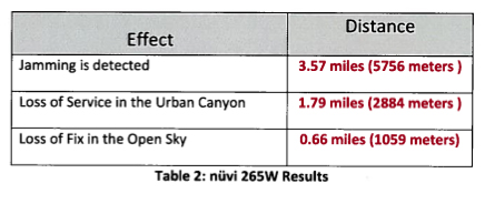
The potential interference is charted here:

Interference to consumer grade GPS receivers

For FAA-certified GPS receivers, the data is worse:

Interference to FAA certified GPS receivers

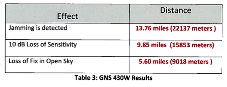
The FAA-certified aviation receivers are more sensitive, therefore, more likely to be impacted.

It makes me wonder, what is going on in Washington?

UPDATE: March 3, 2011, KNX, Los Angles runs with the story: Planned 4G service could cause widespread GPS jamming

MW/SW hybrid stations

There are four of these stations in Canada.  In my scanning of the shortwave frequencies, I have found CFRX on 6070 KHz to put a strong signal into my location pretty much 24/7. At night it is drowned out by interference but daytime is listenable from local sunrise until about an hour before local sunset with a 100 uv signal.  A look at the map reveals the CFRX transmitter site is roughly 300 miles away.  CFRX is a relay of CFRB, 1010 KHz in Toronto, Ontario, Canada.  CFRB does not come in here at all due to protecting 1010 WINS in NYC.

1964 CFRX/CFRB QSL card

What I find very interesting is the station uses 1 KW TPO into a single 50-foot (117-degree) vertical tower.  That is a pretty low-tech transmission facility, nothing like the minimum 50 KW with a 10 dB antenna requirement the FCC stipulates for shortwave broadcasters in this country. Even so, it generates a big useable signal, in the case of CFRX, covering nearly 300,000 square miles very inexpensively.

CFRX has been relaying CFRB’s signal since 1937.  According to the ODXA site, the station uses a Bauer 701B modified to transmit on HF.    The Bauer transmitters were always solid units.  It went off the air in 2008 for several months while the transmitter was repaired, but eventually, it did return.  Obviously, the station ownership finds value in the service and it continues today.

I often wonder why the FCC won’t allow a similar HF relay service here in the US.  Daytime propagation on the tropical bands (75 and 60 Meters (3.9-4 MHz and 4.7 – 5.06 MHz respectively)) would allow low-power relays to cover large areas like CFRX.  Tropical band propagation is such that nighttime coverage may be degraded by interference from other, more powerful stations offshore.  Even so, it seems like a good way to cover a lot of ground in an economical way.

Other Canadian shortwave relay stations:

HF Call signPower/frequencyParent stationLocationPower/frequency
CFRX1000/6060CFRBToronto, ON50 KW/1010
CFVP1000/6030CKMXCalgary, AB50 KW/1060
CKZN300/6160CFGB (CBC R-1)St. Johns, NF4.5 KW/89.5 MHz
CKZU500/6160CBU (CBC R-1)Vancouver, BC50 KW/690

Power in watts, frequency is KHz unless otherwise noted.

I know the CRTC would like to do away with these stations, but I think that is foolish.

Local Community Radio Act becomes law

The President has signed the reconciled bill into law, it will be published in the national register.  FCC Chairman Julius Genachowski promises “swift action” to get the new rules in place.   If this law leads to a bunch of new, live local community radio stations springing up across the country then it is a welcome thing.  With all the rumbling in Congress about cutting public radio funding, LPFM may have some big shoes to fill.  I have to admit, that I am generally a supporter of public radio, however, they have gotten off track (full of themselves) in the last few years.

There are many different requirements placed on the FCC by the LCRA to thread the LPFM needle around translators and full-power FM stations, so it may take a little time to craft new LPFM rules, however, I’d expect to see a filing window sometime in 2011.

If you are considering an LPFM station and are eligible for a license, take a peek at Prometheus Radio Project, which has a wealth of information about LPFM station building.

If you need a good engineer to file paperwork, specify equipment, consult about transmitter locations, towers, antennas, and so forth, drop me a line.  You can find my info and contact information in the About section.

FCC seeks comments on Traver’s Information Stations (TIS)

Another one of those things that might work could possibly provide some service to travelers, but often falls short.  Very similar to EAS, the government officials nominally in charge of the system have no idea of broadcasting.   The Rhode Island TIS on I-95 had an endless loop proclaiming “This is the Rhode Island Department of Transportation Travelers Information System.”   While that was welcome information, in a snowstorm, something about road conditions or perhaps the weather forecast might have been more appreciated.  According to the FCC website, that was WPTJ441 on 1630 KHz with a power of 10 watts.  The transmitter is located at the I-95 rest area on the Rhode Island/Connecticut state border.

The FCC is seeking comments on the current TIS in NPRM 10-203:

We solicit comment on whether to modify the existing rules governing the licensing and operation of Travelers’ Information Stations (TIS) to expand the scope of permitted operations. Since the inception of TIS in 1977, the Commission has authorized TIS operations to permit Public Safety Pool eligible entities to transmit noncommercial travel-related information to motorists on a localized basis. However, certain parties and licensees have sought to expand the scope of TIS operations in order to transmit more general alerts and public safety-related information to the public, including non-motorists. By initiating this proceeding, we grant petitions for rulemaking filed by Highway Information Systems, Inc. (HIS) and the American Associations of State Highway and Transportation Officials (AASHTO) requesting the commencement of a proceeding to amend the TIS rules. We deny the petition for declaratory ruling regarding TIS filed by the American Association of Information Radio Operators (AAIRO), but incorporate the issues raised in AAIRO’s petition into this rulemaking proceeding

The TIS as specified in the 1977 RO docket 20509 FCC 77-414 is outdated for the most part.  The current rules, 47 CFR 90.242 give pretty specific requirements including things TIS stations are not allowed to retransmit, like NOAA weather forecasts.  In one section of the NPRM, it is noted with the currently specified facilities, the average vehicle traveling the speed limit will transit the TIS coverage area in 90 to 120 seconds.  For the above station, I found it was listenable for about 5 minutes, from the time I saw the sign next to the transmitter until it faded out, which works out to be about five and a half miles.

One alternate possibility is something like a carrier current station or a leaky coax setup buried in the median.  Something like that might have more reliable coverage along the highway without blanketing the general area with a broadcast signal.

Again, in Rhode Island, drivers have the option of calling 511 on their cellphone, provided it is a hands-free cellphone.  My only comment about that is when there is a major traffic jam and everyone is dialing 511 to get information, the cellular network will get congested quickly.  Having a broadcast outlet for people to listen to on their car radios would be a more effective way to transmit information to the masses.  As to what information a driver might want; here are a few suggestions:

  1. Up-to-date traffic information including alternate routing instructions in case of a major tie-up.
  2. Up-to-date weather information including roadway surface conditions and possible lodging locations
  3. Up-to-date construction project information including alternate routing instructions for both car and truck traffic
  4. When there are no traveling issues, other general information about rest stops, hospitals, tourist attractions, etc.

The most important thing is the information is up to date and relevant to a traveler.